| |
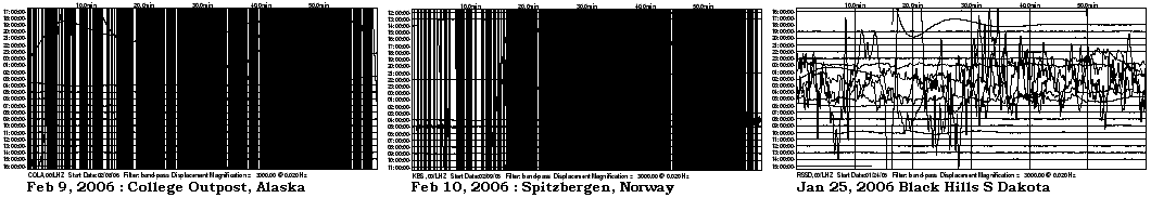
I watch the LISS live seismosgraphs frequently, and have noted lately a new pattern. Almost daily some spot on the globe turns black, in concert with a small global shuddering, usually at 6 UTC. As Planet X is found to the right of the Sun, lately, this coincides with the gripping of the Atlantic Rift about that time, as the rift swings to the East in the Southern Hemisphere. But what stands out, recently, is that these points of stress, a seismo turning black, are mostly along the edges of the N American plate. The seismos along the N American plate boundary in Russia have been extremely wobbly for months, and lately the Black Hills seismo also, for almost a month. Is something about to pop, there, on the N American continent? I've kept a record, when a single spot turned black. This seems outside of the sweep pattern, which occurs every 3 weeks and runs for a week. 1/31 Korea 2/1 Greenland 2/2 Galapagos 2/3 to 2/6 (Live Seismo site down) 2/7 Greenland 2/8 Zambia 2/9 Alaska 2/10 Norway
We have discussed what we call the stretch
zone, where a land mass is pulled apart so that the rock flakes pull
across each other, silently, creating sinkholes and rifts and manifesting
as broken gas and water mains and derailing trains. These stretch zones
have dramatically expressed themselves in the African Rift area and in the
SE United States and in the UK during the past couple years. When Planet X
arrived in the inner solar system in 2003 and began seriously tugging at
the highly magnetized Atlantic Rift, it accentuated this stretch on either
side of the Atlantic. What went unstated during these discussions is why
a stretch zone occurs. Look at S America, on the large S American plate.
As the Atlantic is pulled apart, the Pacific compressed, it is required to
have the upper part migrate to the West more than the tip, which is
anchored at Antarctica. It moves as a whole, in the main, crunching the
small plates in the Caribbean and Central America as it does so and
popping the plate holding the Galapagos Islands which lies just to the
west of S America. It can move, in short. But what of the African and N
American plates?
The African Rift is caused because Africa is not free to move.
It is bulbous at the north end, and comes to a tip at the south end. It is
anchored at the south end, at South Africa, so when the Atlantic pulls
apart, the bulbous northern part of the African plate moves directly
eastward, yawing open the African Rift, along with the Red Sea, which is
also widening. This inability of plates to move during the
ripping apart of the Atlantic and compression of the Pacific is what will
create a new rift up through Pakistan and above the Himalayas into Russia
during the pole shift, equivalent to the St. Lawrence Seaway in N America.
The Indio-Australia plate moves in the direction of the Himalayas, diving
under them. Hawaii rises up during compression of the Pacific,
so can move, if only up. Japan likewise is forced up, violently
so, during Pacific compression. The Antarctica plate, as we have
mentioned, is pressed down in the Pacific so will pop up on the Atlantic
side, creating new land there ultimately during the pole shift.
 The
giant plates of N America and Eurasia are locked against each other,
unable to rotate against each other due to their shape.
Slip-slide along the West Coast, measured as a creep by geologists, is due
only to slight adjustments along that edge of the plate, primarily due to
adjustments within the small plates to the west of the N American plate,
which move to accommodate pressure. The N American plate does not move,
pre se, but other dramas occur. We explained, months before it expressed
enough to show up on IRIS charts, the Earth
torque caused as the N Pole continuing to rotate to the East while
the S Pole was held back by Planet X, tending to open the globe like a jar
of pickles. This creates a diagonal stress on the N American
continent where New England is pulled to the east while Mexico is pulled
to the West, so the New Madrid is put under slip-slide stress where one
half, east of the Mississippi, will move toward the NE while the other,
west of the Mississippi, moves toward the SW. The virtual hook of land in
the N American continent near the Kamchatka peninsula is solid rock and
will not snap off to become a separate land plate, nor would this ease the
deadlock along the N American and Eurasian plates even it if did. These
massive plates cannot move.
The
giant plates of N America and Eurasia are locked against each other,
unable to rotate against each other due to their shape.
Slip-slide along the West Coast, measured as a creep by geologists, is due
only to slight adjustments along that edge of the plate, primarily due to
adjustments within the small plates to the west of the N American plate,
which move to accommodate pressure. The N American plate does not move,
pre se, but other dramas occur. We explained, months before it expressed
enough to show up on IRIS charts, the Earth
torque caused as the N Pole continuing to rotate to the East while
the S Pole was held back by Planet X, tending to open the globe like a jar
of pickles. This creates a diagonal stress on the N American
continent where New England is pulled to the east while Mexico is pulled
to the West, so the New Madrid is put under slip-slide stress where one
half, east of the Mississippi, will move toward the NE while the other,
west of the Mississippi, moves toward the SW. The virtual hook of land in
the N American continent near the Kamchatka peninsula is solid rock and
will not snap off to become a separate land plate, nor would this ease the
deadlock along the N American and Eurasian plates even it if did. These
massive plates cannot move.
The stress on the N American plate will resolve by ripping. Ripping the
St. Lawrence Seaway open. Pulling the SE down into the crumbling Caribbean
and into the widening Atlantic, as neither of these sinking fronts will be
able to support the edge of the weighty N American plate. There is pressure
along the West Coast, of course, and as the N American plate confronts the
compressing Pacific, this will only result in the predictable volcanic
increases and West Coast earthquakes. But the primary drama preceding the
pole shift will be the ripping action that a plate unable to move must
endure. The notable area of catastrophe during this is the eastern half of
the continental US. From Houston to Chicago to New England, the diagonal
pull will tear the underpinning of cities and create a catastrophe for the
US that will make the New Orleans disaster appear trivial. A widening
Seaway also does not affect just those land masses bordering the Seaway,
as buckling occurs inland and afar. What does man assume caused
the Black Hills to be so rumpled, with the appearance of a recent
bucking and heaving? This is the center of a land plate! The tearing of
the Seaway does not end at Duluth, MN, it travels underground to S Dakota!